Geography of the Lands of Warlderia
The known world consists of two large landmasses, West & East Warlderia, and two partially explored landmasses to the north and south called Helltenen (Hell-ten-en) and Kylma (Keel-ma).
The known world is based in the southern hemisphere of the ‘planet’ with the latitude of central Warlderia being approximately 45 degrees south giving it a convenient European temperate climate overall.
The Southern landmass of Kylma starts at a colder 55 degrees south while the northern Helltenen is at a warmer 35 degrees south.
In a reversal of the normal European view point north of the known lands lie the tropics while to the south lie the arctic wastes
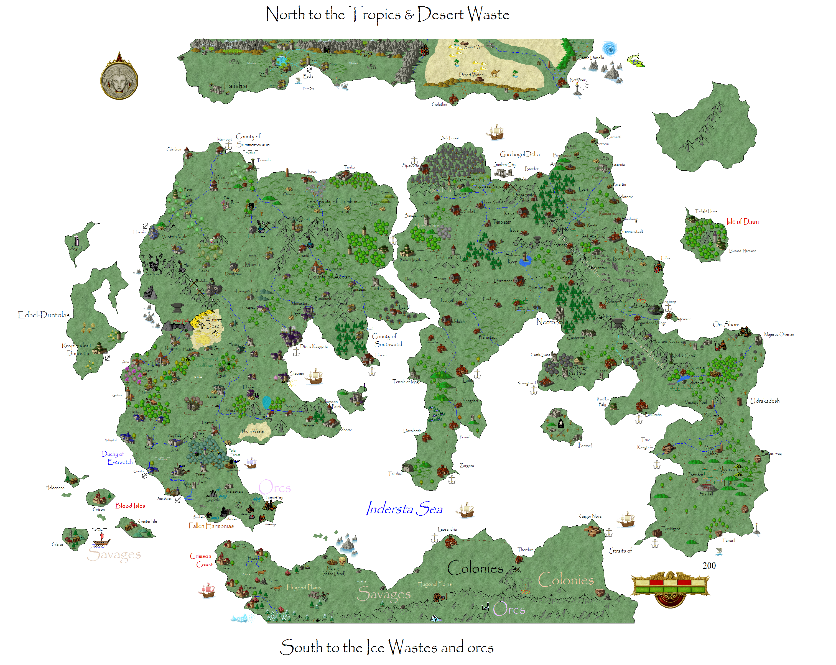
Kylma stretches off to the south and gets colder the further one travels. A thin strip of colonised land on the north shore runs south to the imposing Orcbane Mountains. Beyond the mountains are the cold wastes and orc hordes though they have been peaceful for decades locked in internal wars.
Little is known of Helltenen beyond the strip of land on the southern end of the landmass which has colonies on them. There are savage humans present and certainly a whole range of monsters but to the north lies hills and then a great desert. The desert is home to lizard men and scorpion folk. Beyond the desert is rumoured to be a great and wealthy river kingdom but this is just rumour.
Further information on Helltenen
Central to the known world is the Indersta Sea which is surrounded by Kylma and West and East Warlderia to the north. All the major human cultural groups border it and it is the main artery of transport. To the north is the Straits of the Kraken, an ancient name of lost meaning.
To the west and East lie unknown lands but that can easily be filled in with new ideas or convenient existing campaign lands….